Experience the real EthiopiaBook a Trek Now
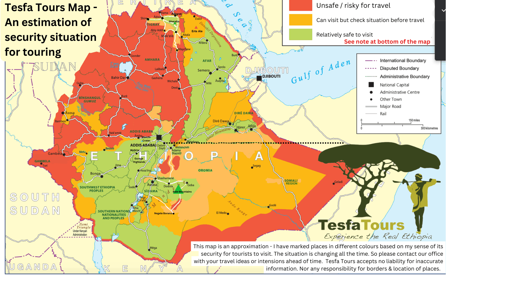
Security across Ethiopia (approx)
The last years have been very hard for tourism in Ethiopia. Since 2016 there has been disruption, conflict, states of emergency and of course COVID 19. There have been insurgencies and conflicts affecting almost all corners of the country.
However one thing has remained true, which makes Ethiopia stand out from many other countries (Kenya, Mali, South Africa and Egypt to give some African examples), tourists are not the target of any groups.
The exception to this is a couple of occurrences in the Danakil – a lowland part of Ethiopia that is unlike the highlands in every way. You can read from authors like Wilfred Thesiger about Afar people (The Danakil Diary: Journeys through Abyssinia) and their “ferocity and intolerance of outsiders, once accompanied by a habit of cutting off the testicles of any foreigner found in their territory” as described in the Irish TImes article. There was a kidnapping in 2007, a deadly ambush in 2012 and then possibly a mistaken shooting in 2017.
I propose this page not to scare off prospective visitors but to give sound fact based advise (where I can) and use my judgement as to relative safety. Of course no travel is without risk, and in fact staying at home involves risk. Recently I was travelling with an Irish guy who had been living in Huston Texas, and felt Ethiopia was far safer than the streets of Huston. He is almost certainly correct, the chances of you getting shot in Ethiopia are so small in comparison with living in the USA. But sadly travel advisories from our respective governments do not reflect the realities of life, and do not get written based on statistical probabilities.
As a way to assess my own feelings about the safety of an area I would think about whether I would travel their with my family or not. I would not want to advise any clients to travel somewhere I would not go with my own family.
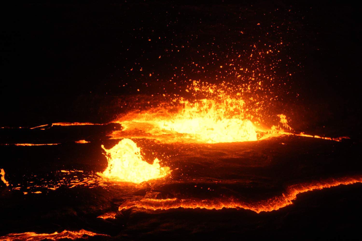
The caldera on Ertale – feel the heat of a live volcano
So let us start by looking at the Danakil and the safety of trips there. In fact this is quite complex as if I was preparing a risk analysis I would look at a range of issues. I might start with the geology, after all the Danakil is a volcanic zone in the heart of the Great African Rift Valley -well you knew that – thats why you are going – to climb a volcano called Erta Ale and watch lava bubbling a 100 meters away from you! I am not a vulcanologist but I would expect that that is a lot more risky than sitting at home on your sofa watching the latest episode of Strictly Come Dancing (never watched it – maybe it has a health warming!).
Then there is the climate – the intense heat. Danakil is after all one of the hottest places – if not the hottest – on earth. I know that at least 2 tourists have been left behind by oversized and badly run tour companies in recent years, and although they realised after a time and went back, one died on her way to Mekele and the other was never found – presumed dead! But with that extreme temperature (its not always that hot but can be) comes risks. If peoples hearts are not that strong, or they have another underlying health issue, the Danakil climate could be the straw that breaks the camel’s back (more likely block of salt here).
The final risk is traffic accidents – it shouldn’t happen in an empty place like Danakil, but a car did suffer a blow out, and overturn killing one of the people riding on the roof!
But you know what is crazy is that the majority of these accidents have happened to one tour company!!! So booking with a reputable tour operator- we can arrange a trip for you!
Hospitality in Tigray community guesthouses
This a fascinating part of Ethiopia, where the earliest churches are found, some cut into the rock in cliffs, most famously in Gheralta. Tesfa has helped local communities to build simple guesthouses just to the north of Gheralta in the Agame mountains – also where more churches are found in the cliffs. It is also home to the obelisks and tombs in Axum where the massive stone architecture makes me think of ancient ruins in Peru and Mexico as well as Egypt. But more recently Tigray was overtaken by conflict as the regional forces battled with federal forces and the Eritrean Army. This war came to an end in Nov 2022 with the Pretoria Peace accords, and although the implementation has been slow and incomplete fighting has come to an end. I visited the area twice after the situation stabilised: in March 2023 to see the effect of the war on our guides, the community guesthouses and the communities themselves. I then went back with a team of friends: other tour operators, guides and Betty from our team, to trek through the Agame mountains staying at the 3 guesthouses that are fully operational, and the lodge in Hawzen, and to visit one of Ethiopia’s most spectacular churches – Abuna Yemata Goh and go on to Axum itself. We were able to report that it was safe and we were made so welcome. The hotels we stayed in were fine and the services we received – food, electricity, internet – were all good. We flew into Mekele and out of Shire – itself an hour out of Axum (as Axum’s runway is not serviceable yet).
The overall situation in Tigray is safe, although I would completely avoid the border with Eritrea, and the disputed territories in the extreme west and south east of the region. This is because the areas are militarised and tense not due to ongoing fighting. From Shire heading east to Axum, and then the central area with roads to Gheralta and Adigrat are fine (but not north of the Adigrat road) and from Adigrat & Gheralta to Mekele is also safe for travel.
Amhara region is a land of mountains and gorges. The Nile gorge carves its way in a great arc from Lake Tana, eastwards, then bending south and finally west and on out to Sudan. The Tekeze river begins its journey in the mountain s east of Lalibela and makes its way north around the Simien Massif and out to Sudan. These great rivers and their tributaries carve up the region making. land travel slow but exciting. Currently there are militias in many of these areas and travel is not recommended. At no time have tourists been a target, and everyone would try to keep you out of harms way, however roads are closed and travel is disrupted. So sadly for the moment we do not recommend travel here, although a few hardy tourists are making their way up on flights to see Lalibela, Gondar and the Simiens. In recent weeks (early November) there was fighting in and around Lalibela which sadly illustrates how unpredictable the situation is in the region at this time.
Travel here largely remains a good option. Harar is a friendly medieval walled city in the mountains, one of the holiest in the Islamic world, with a myriad of mosques and an old city with narrow alleyways that mean it is free of motorised traffic. Dire Dawa, which has the airport and is a 40 minute drive away by contrast is a lowland town with wide treelined avenues, a curious French built railway station and a busy market.
Visitors to Harar can also take an excursion to Babile to see the camel market (twice a week on Mondays and Thursdays) and to the Elephant Sanctuary (not a sure sight) and several other excursions, but most people will see the hyenas that are fed on the edge of the city each night, and you can get up close and personal. This brings me to the question of security… apart from the unsettling feeling of being right next to an apex predator whose jaws can crush bones, the Harar area is secure, although we will need check on the current situation around Babile as there can be ethnic issues in that area as it falls on the Somali / Oromo border.
The Awash area is on a the border of the Afar people and the Kereyou (an Oromo people). Both are pastoralists with distinct identities and fiercely proud… and armed. From time to time conflicts break out between them, often over grazing rights and access to water. At such times we avoid going into the northern part of park, however driving to Doho Lodge and Awash Falls Lodge is safe. As a precaution in safe driving along the main road and going to the lodges, we insist that it should be done a few hours before sunset. Further west from Awash is the town of Metehara and this area has seen disturbances in the past, so once again we advise to drive through this area well inside daylight hours.
There is a park further east – Aledeghi park – is also on the Afar / Oromiya border and is subject to insecurity. Here we would need to clear the feasibility of visiting in the weeks and days prior to a trip.
The Great African Rift Valley runs through Ethiopia with a chain of very different lakes in it. The main section runs south from a town called Nazeret/Adama towards the Kenyan border. The lakes include lakes: Ziway, Langano, Abijiata, Shalla, Hawassa, Abaya, Chamo, and finally in the Omo Valley, Chew Bahir, and the upper part of Lake Turkana. For this section I will refer to the first five: – lake Ziway to Lake Hawassa, so by road from Mojo (always love the sound of that place) through Ziway (or Batu as it is now called) to Sheshemane and on to Hawassa. This advice can also taken in the town nearer to Addis – Bishoftu (formerly Debre Zeit) which also has a cluster of lakes, most of them crater lakes. This area is mostly inside Oromiya region, which is Ethiopia’s largest region and biggest ethnic group. There is a long standing Oromo movement for greater autonomy and more of a say in the governance of the country, which spawned a guerrilla movement known as the Oromo Liberation Army (OLA) -(frequently referred to as Shene) who in Nov23 tried and failed in negotiations with the Ethiopian Government. While the main roads, towns and hotels and lodges are generally safe there is some concern about this area and we try to keep informed about the situation and ensure that we are not driving near to dusk (except on the final stretch to Addis between Bishoftu and Addis on the highway which is a very busy road and less of a concern).
We do travel on these roads frequently but observe the precaution of not driving late in the day. However there is no security to travel far off the roads into surrounding countryside areas at this time unless its a known tourist destination (as in the main lodges and Shalla -Abijata park).
The area around Hawassa (Awassa) is in Sidamo Region, a new region and not affected by this conflict except right along some of its borders. The city is modern and safe. We have just done a recce trip focusing on the mountains to the west of the lake and found it to be safe. In the Sidamo area there are nice places to stay and visit – Aragash Lodge and Wondo Genet to the east and a lodge on the lake to the west. We recommend travel in the Sidamo region.
A little to the east of the lakes is a parallel road south going from Nazeret/Adama through Assela to Dodola. This is much less travelled by tourists, and the mountains off to the east of the road are not safe places to trek at this time. I have them earmarked for some recci trips – but not just yet. However the main road should be Ok with the same proviso as with the road to the west.
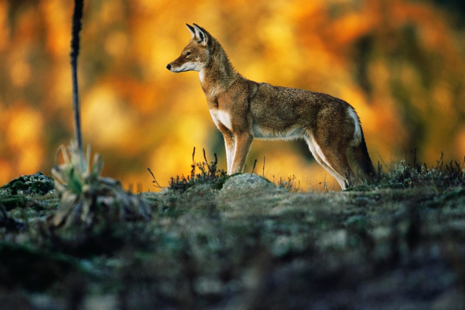
NATURE PICTURE LIBRARY / ALAMY, Ethiopian Wolf in Bale
To the south east of the Rift Valley lakes is the Bale Mountains, which form the water tower and source of rivers running south east from Ethiopia. This high moorland is the main refuge for the Ethiopia Wolf, the world’s rarest canid. With the thick forest on its south and eastern slopes it is a wonderful place to visit, and currently is safe. It is vital to work with local guides from these mountains and we have a great team here. While the park itself is safe, it is not recommended to drive on the road south from the park beyond Delo Mena . We do not recommend taking the roads to the east nor north east from Bale, but driving from the Rift Valley lakes side is the best way to access the park and is the most direct.
The former Southern Nations, Nationalities and Peoples Region (SNNPR), was just now was subdivided into several new regions. The actual lines of these divisions and whether or not a people got their own region has caused protests. However there is not the level of conflict seen in other parts of the county and all governmental advisories put this are in a green or equivalent zone. Generally there is no concern about travelling in this former region. however there have been a few flash points especially along borders with Oromiya.
The southern Rift Valley includes the areas around Arba Minch and Konso, including the Chencha/Dorze mountains and the visits to Lake Chamo. These places attract a lot of visitors, as they are great attractions their own right and it is a gateway into the Omo Valley. It is also one of the safest places to visit and Arba Minch has a good airport with regular flights so people can fly in direct from Addis. Konso over the years has had disturbances which have stopped people visiting at times. This was an internal ethnic and political issue and not as concerning as those in other parts of the country.
These lands to the west and south west from Arba Minch are home to a number for Omotic peoples, whose tribal attire, and lives have attracted a lot of attention. It was a remote and inaccessible land until more recently but now development has meant new roads and easier access. However as a result some tours seek out even more remote places. This area does not suffer from the armed conflict that has affected other parts of Ethiopia, but traditional inter tribal raiding, exacerbated by land being taken for sugar plantations and other large scale agricultural projects and the effects of the damming of the Omo river on traditional agricultural practices, means that the area is somewhat unpredictable. Add to this that the tribes who were always armed are now getting cheap weapons from across the border in Sudan where the conflict in North Sudan has meant that guns are cheaper and plentiful. Visitors should be sensitive to the situation and all professional guides and drivers would be mindful of this. The main town, Jinka, also has an airport with regular flights which makes this are more attractive. We have developed a tour that is sensitive to the local communities and not about pointing cameras at tribal people.
Going across the Omo and more north west to the west of the Omo national Park – you come to the Suri / Surma places such as Maji, Tulugit Tum and Kibbish. This area is much wilder and access is on bad roads, with risks of being cut of or stuck. There is obviously a greater degree of unpredictability in these parts, and there is more of a history of conflict here. Heading north from this area take you to the main road at Mizan Tefari and the access to this part of the Omo can be made through the road from Jimma to Mizan Tefari.
Gurage girls at Meskal
These zones are safe places for travel. At Tesfa Tours we have been doing a lot of trips in Gurage, having created a homestay version of our community tourism there. The people are very friendly and the area is safe. The drive to Gurage takes about 3 hours from Addis and as there is no airport that is the way in.
This area runs from Addis west towards the borders with Sudan. In general as you go further west the area becomes less and less secure. To the west of Addis many people visit Wanchi Crater and Menegesha Forest and visits here are safe. As far as Jimma and down to the park at Chebera Churchura Park the area is safe. As usual adhere to the principle of not being on the road later in the day, and its best to travel in a marked tourist car. West from Jimma the road takes you to Bonga and Mizan Teferi and the main road is fine for travel. But its good to get specific advice for locations off the main road. Further north and west it is not advisable to travel without really getting assurances from those who really know.
These western lands along the south Sudan border are very unstable, in part due to having unstable Sudan on their border. These states are very different from highland Ethiopia to the east. However this is not somewhere we take people at this time.
Ethiopia used to be one of the safest countries in the world and Addis Ababa as its capital was surprisingly safe. Times around the globe are changing, costs of living are increasing and the number of marginalised people at the bottom end of the spectrum is increasing. Ethiopia is suffering from t hat too, and the economic woes of the country are increasing costs of basic food items, rent and transport – in fact everything – even faster. So its no surprise to find that petty theft – bag or phone snatching and scams are on the rise. Keep you wits about you and you should be fine. More details are in our ‘visitor’s brief’ which we can share with you. Ethiopia, and especially the countryside is still very safe in terms of personal safety, and the level of honesty of Ethiopian people is still exceptional.

We wish all our friends, customers and our team members across the country a happy Christmas time – Melkam Gena (Happy Christmas know as Gena or Lidet in Ethiopia). As across the Orthodox world it is celebrated a few weeks later than in the west. But this year (2016 which started on 12 Sept), is […]
We wish all or friends, family, supporters and partners Melkam Addis Amet: Happy New Year. Today – as the thirteenth month (Pagume) ends we say goodbye to 2015 and welcome in 2016 in the Ethiopian Calendar. In this past year (2015), known as a Lukas year, (there is one for each of the four evangelists) […]