Find our more about our responsible tourism policyRead Now
In the basalt mountains around Lalibela, communities farm in the age old way with ox-drawn ploughs, and had tools. Life for the farmers is hard, but they have a ready smile and love to receive guests. Tesfa Tours offers three different walking holidays in these highlands. However we will happily put the treks together to make longer or more varied walking holidays.
Lalibela is one of Ethiopia’s most sacred sites, with a network of 11 churches hewn into the bed rock. It was constructed in the late 12th century by the Saint-king Lalibela. Previously it was known as Roha (strangely reminiscent of Lord of the Rings , when taken alongside the next capital: Gondar).
A trek to the Tesfa sites can be combined with a visit to Lalibela (and Gondar). Guests can be picked up from Lalibela airport and whisked off to the trek sites or they can be picked from Lalibela town itself.
Get a quote for Community Trekking in Wollo (Lalibela) nowPick either an ambling walk through the landscape of western Meket where Tesfa first started working, or a more rugged trek between Eastern Meket and and Lasta (Lalibela’s district) and Gidan. In this more eastern part the landscape gets a bit wilder but you are still in farming areas, and hosted by the communities.Just north east of Lalibela is the Afro-alpine mountain: Abuna Yoseph. A trek up here takes you onto the moorland meadows home to the iconic Ethiopian Wolf and other wildlife, but again your hosts are still the communties.
( Click on site names for more details )
Mequat Mariam, a remote parish based around the church of St. Mary's of Mequat, was the first community site to begin hosting guests in 2003 and is the most westerly of the Tesfa sites. The tukuls (thatched round cottages) are set on a promontory of the Meket plateau with staggering views to the west and south. A small troop of Gelada Baboons patrol the escarpment, and a troop of Vervet monkeys sometime come up for a visit. Lammergeyers, vultures, buzzards, kites, ravens and many other birds soar over the site.
Mequat Mariam boasts a 'rock bar', a smooth sheltered ledge that is warmed by the afternoon sun and invites guests to sit with a sundown drink a watch the golden glow at the end of the day turn red as the sun sets over Mount Guna.
Most people start their trek to Mequat Mariam at the community called Werkhaye Mariam. Here the local community provide a sit down lunch of local fare: local enjara (a sour pancake made from local grains notably teff) and vegetarian stews, washed down with a traditional cup of hand roasted & ground, freshly brewed coffee. Soft drinks, water and beer are for sale.
From Werkhaye it is a 3 hour walk to the first site, following well beaten trails through the landscape.
It is a full day's walk between Mequat to the next site: Wajela - about 7 hours walking + stopping time. The walk combines sections following the escarpment edge with incredible vistas and sections across the meadows and grazing land. There are plenty of opportunities to see the communities at work. On the way Meskal Mikael community provide a lunch much like that at Werkhaye Mariam, but besides a cliff edge with ribbons of water (except in the driest seasons) dropping of the edge into the boulder strewn land below.
The second community-run site is Wajela, which began hosting guests in 2004.This quiet village sits just below the plateau top on a fertile ledge. The spot chosen for the tukul camp overlooks an intriguing cave complex and the old church of Werketa Mariam set amongst Juniper (a large indigenous pine tree) woodland. Wajela also boats an old acacia wood, besides which they have built a small church. This cosy site is set alongside a village, and community life goes on around the tukuls.
From Wajela to Aterow is a lovely 5 hours walking, mostly along the escarpment edge with the steep basalt cliff edge eroded into protruding blocks.Lunch is served by the community at Gicha by a big Giyorgis church and its lovely wooded church yard perched on the cliff edge.
In 2006 the community at Aterow finalised their tukuls. The site chosen for the tukul camp overlooks a gentle valley that comes from the plateau top and then below the site drops into a dramatic gorge. The river in the valley takes the plunge and although the resulting falls are not visible from the camp they can be reach by taking the short steep way down into the valley below.
This is a great place to see Gelada baboons, who come up from the cliffs and gorge below. There are always birds of prey on the thermals too, and with some luck you will see the little Rock Hyrax warming in the sun in the morning.
A vehicle can pick you up from Aterow, either near the site if you have to rush for a plane or if you have a few hours you make the steep descent to the waterfall, and follow the gentle valley eastwards until your path reaches the Lalibela road. It is little over an hour from here to the airport at Lalibela, maybe 90 minutes to Lalibela town itself.
If walking on to Yadukulay, the fourth site which started receiving guest in 2007, it is a steeper descent into the valley which is full of irrigation channels and fields of green onions and other crops. From there a short climb of 30 minutes or so takes you up the little twin peak on which the site is built. It gives you a great 360 degree view up into the valley that narrows to the east or west towards the sunset over the lowlands, or off the cliff faces to the north and south. It is not a long walk from Aterow, depending on your comfort in the descent it can take about 4 hours. So you can reach there for lunch and either elect to relax in the afternoon or go exploring in the villages below.
The Yadukulay community is near the village of Taja, about 50km south of Lalibela. This can serve again as the trek end, or one can continue on to the stunning site at Boya. This is described in the next section - Rugged treks.
A good start is the lower altitude site of Yadukulay (around 2,600 meters). This can be reached in about an hour from Lalibela. You can be dropped off very near the site (30 minutes walk), or met just over an hours walk away in the village of Taja. Buses also ply this route so you could get an early morning bus from Lalibela.
Yadululay is uniquely placed on one of two small twin peaks on a hill rising out of a small valley cut into the escarpment. To the west are the lowlands, actually about 2,000 meters above sea level, where rivers have cut down through the basalt escarpment to further levels of rock. To the east the river valley narrows as it is constricted by the plateau, finally ending in a waterfall that is a hard walk to reach due to the bouldering (scrambling over massive boulders) as you get further up the valley. Into the cliffs are built a few churches, hewn in rather more rudimentary style than those in Lalibela, from the bedrock.
Leaving Yadukulay on the first full day, you cross the river below the site and take a step path up onto the escarpment to the south reaching the top at around 2,800m. From here the path is less steep but gradually climbs toward the lunch stop where the Dufti community serves a well earned lunch on the edge of the escarpment facing west. Lunch is enjara with vegetable sauces, with a coffee ceremony at the end. Water,beer and soft drinks are available. From up here you can see the rivers beginning to cut down into gorges and speculate about the geological process that have taken place to create this landscape. The afternoon takes you through fields and meadows and back on to the edge as you wind round to Boya community site.
Boya like Mequat Mariam has a dramatic westerly views and is a great place for sundown drinks watching the day come to an end - but wrap up at 3,200 meters it can be cold when the wind blows off the plateau.
The next day is a bit easier as it is more or less on the flat, walking either across the plateau or along the escarpment. There are great views to the north of the Abuna Yoseph massif - next highest after the Simiens and Bale mountains with its peak at 4,300m. A lunch like that at Dufti, is served by the community at Waro Mikael. The afternoon walk is more along the edge with the views of Abuna Yoseph and the valley between. This is a great stretch for seeing quite large troops of Gelada Baboons.
As you get close to Aina Amba the afternoon sun lighting up the cottages makes a welcome site, and the thyme flavoured tea makes with snack food is even more welcome. Aina Amba itself is situated on a small rise on the edge of the escarpment facing the Geneta Mariam ridge and Abuna Yoseph. The church for the community at Aina Amba is dedicated to St George (Giyorgis) is one of the few with a thatched roof along the trek.
From Aina Amba you can be picked by car and whisked off to Lalibela, even reaching the airport for a 10am check in if needed. Or the trek can continue to the east. Or for those more adventurous you can trek north down into the river valley and up to Geneta Mariam, from where you are much closer to Lalibela.
Continue to the east
Carrying on along the increasingly beautiful escarpment you come to the lunch stop at Melkidefer which is ready to serve a nutritious local lunch. And the walk is well worth it. There is a pretty churchyard at Adisge with giant Erica woodland (Erica arboreal) among the vegetation just before you reach lunch.
Your trek can end there and a car pick you. This part of the road is closer to Weldiya (and Dessie) so if your journey is going to or coming from this side - Melkidefer is a good trail-head.
The next site, and most easterly is at Kurtain Washa, it is the most recently completed site. The scenery is increasingly dramatic as the valley to the north narrows and the land gets increasingly rugged and craggy. The altitude at Kurtain Washa is about 3,600m. There are red-hot pokers growing here and other higher altitude plants. As the landscape gets more rugged so the chances of seeing wildlife increase - there are many Gelada baboon around here, and a good chance to see the shy Klipspringer.
Kurtain Washa is about a 1hour walk from a settlement called Ahun Tegene on the main road from where you can be picked up. It is the first site in Gidan Woreda.
Geneta Mariam is built on a low ridge jutting out from one of the main spurs of Abuna Yoseph that runs southwest from the peak. The community at Geneta Mariam will make you welcome and serve you much needed snacks on your arrival.
There is a beautiful rock church carved into the spur of mountain. It is one of the more interesting churches that lie in the Lalibela area, and has frescoes of elephants inside that were said to have been used in the construction of the church. Were there wild elephants in the Tekeze Valley? Were domesticated elephants bought to Ethiopia from India or did they come with the Napier Expedition?
Further up the mountain another fascinating church is waiting to be explored: Mekina Medhane Alem. This church is a built church in the old style (as Debre Damo & Yemrehane Christos) with painted wooden struts on the roof. It is in a cave which has a pool of water just inside the opening, with the white washed church behind. Again there are interesting frescoes.
To get to Lalibela from Geneta Mariam you can either arranged to be picked up from below the site (its about 45 minutes to either the airport or town) or you can walk the first 15 kilometres or so (about 3 hours) of the rough road, to the junction with the asphelt toad and get a shorter lift from there.
To head onto Abuna Yoseph see the section on mountain trekking
Geneta Mariam is one of the Tesfa sites that remains open during the rainy season and we are able to arrange special visits for one or two nights to Geneta Mariam with guided exploring of the village and the area around it. Geneta Mariam is in Lasta Woreda.
From Tadios Amba the walk on down to Geneta Mariam has some steep sections with views of the valleys opening up. There is an important church on this ridge: Mekina Medhane Alem, built in a cave and of the old style like Debre Damo and its more famous cousin in the area Yemrehana Christos. Further down the ridge on the edge of the village of the same name is the church of Geneta Mariam itself. Geneta Mariam is home to another of the Tesfa community guest houses, built on the spur of the escarpment just west of the village. From Geneta Mariam you can continue to Meket or head back to Lalibela. Its a 25 minute drive to the airport - so it is easy to catch the morning flights from here.
From Agaw Beret it is a lovely walk to Tesfa's new site - Tadios Amba which is on a ridge just to the south of the peak. This site is remote and has lovely views back along the south west flowing valley and back towards the peaks. Along the walk to add to the scenery are some basalt outcrops: volcanic plugs providing evidence of the volcanic origins of these mountains.
Nearby is the Agaw Beret site, which was finished in 2012 (constructed by Frankfurt Zoological Society). This guest house/mountain refuge facility is run as are all the Tesfa sites by the local community and is nestled in a grassy area below the peak. You can rest here on arrival and go out for further Wolf spotting walks later and early next morning. Its often best to climb the peak next morning as in the afternoon cloud often builds up, reducing visibility.
The following day you should make an early start and walk along a well trodden path to the village of Wedebiye and its school. After this you really begin to get above the habitation and reach the mountain moorland.
It is probably 3 hours walk to get up to the Afro alpine meadows where big tufts of Gwassa grass and Giant Lobelia grow and Giant Heather trees grow on the slopes. You may elect to climb the smaller of the sharp Zigit peaks on the north west side of the massif (4,030m/13,220ft) in the morning. Between the two Zigit peaks is an extraordinary outcrop of basalt rock, broken up into pentagonal sided pillars.
From here you can walk along the northern side of the mountains home to big troops of Gelada baboon (groups of least 200 can often be seen.)
Now you are in the range land of the rare Ethiopian Wolf - you may hear their bark or be lucky and catch a glimpse of this most endangered canid. There are also big meadows of Giant Lobelia (like a massive cabbage on a stem) and in the distance the peak at Rim Gedel. (We have marked this on Google Maps!)
The land gradually rises towards the peak before a steep climb up the last hundred meters or so. Once you reach the 4,300 meter peak the panoramic view makes it worth the effort.
By the time we got down from the peak it was the ideal time to spot the Ethiopian Wolf, and the area to the south and west of the peak is one of the best places to see these illusive wolves.
ESFA has developed a 'base camp' for exploring the mountain, a few hours walk from Lalibela town. The base camp at run by the Ad Medhane Alem community is perched on the escarpment edge at just over 3,500m (11,500ft) overlooking the ridge that links Abuna Yoseph and the Ashetan Mariam peak that rises from Lalibela town.
In June 2008, Rita and Evelyn from Austria (pictured on left) were Tesfa's first clients to visit Abuna Yoseph, staying at the Ad Medhane Alem site.
The trek typically starts by the Seven Olives Hotel in Lalibela. Here you will be met by members of the community with donkeys to carry your luggage. The walk quickly takes you out of town and up onto the hill behind. The path up to Abuna Yoseph goes through agricultural land and some woodland. Higher up it goes through a lovely stretch of Giant Erica/Heather (Erica arborea). These heather bushes can grow into 5 meter high trees and form a highland woodland that is becoming rare as land is cleared and firewood gathered. This woodland is protected.
Above the Erica wood the path climbs onto a narrow basalt ridge (photo above) and onto a narrow plateau. Here you may be lucky and see Gelada baboon on the southern slopes, and very excitingly 'Netch Zinjaro' - which translates as White Baboon - can sometimes be seen not 50 meters away on the northern slopes. These white baboons are Hamadrus Baboons. At over 3,000 meters this is an unusually high altitude habitat for the Hamadras Baboon.
Beyond this ridge is another climb to reach the Ad MedhaneAlem site. Once there the views are magnificent - back along the ridge and on to Lalibela.

Lunch Stop
Mountain Peak (Closest Site - Agaw Beret)
Not an accommodation site
All our treks can be tailored to your needs.
Get a trek quote nowThis payment includes accommodation, food: breakfast, simple picnic lunch (or where developed, a lunch stop with another community), snacks on arrival and dinner, local beverages (tea and coffee), guide and pack animals or porters to carry luggage (a reasonable amount only – max 20kgs- in soft bags if possible).
Payment excludes bottled drinks (bottled water, soft drinks, beers, wine etc), entry fees to local churches (if you wish to enter) and transport to the start of the trek and back from the end where it is required.
On the mountain trek it is advisable to bring good energy snack food for the high altitude days.
| Category | From 12 Sep ’22 till 11 Sep ’23 | From 12 Sep ’23 till 11 Sep ’24 | Note |
| Adults (16yrs+) | 3200 + 96 (15% VAT on TT 20% ) = 3,296 | 3400 + 102 (15% VAT on TT 20% ) = 3,502 | Per 24 hours or part of |
| Children (12-15yrs) | 75% = 2,472 | 75% = 2,550 | Per 24 hours or part of, with adult accompanying |
| Children (3-11yrs) | 50% = 1,658 | 50% = 1,700 | Per 24 hours (Solo fee will apply if only 1 adult) |
| Children under 3 | Free | Free | (Solo fee will apply if only 1 adult) |
| Charge | Amount | How charged | Note |
| Late booking fee | 400 ETB | Per booking | Booked with 3 or 4 days notice |
| Last minute booking fee | 800 ETB | Per booking | Booked with 1 or 2 days notice (not always possible) |
| Personal guide supplement | 900 ETB | Per group per night | Own guide for small group with 4 or less people |
| Solo guest supplement | 900 ETB | Per guest per night | when 1 person on trek (or adult with young child) |
| Guide transport perdiem | 500 ETB | Per guide | Guide’s travel allowance if not able to travel with clients |
| 1 adult (solo) | 900 ETB | per person | Extra payment to do additional trek from before the normal start or beyond the normal finish |
| 2 adults | 600ETB | per person | |
| 3 adults | 460 ETB | per person | |
| 4 adults | 350 ETB | per person | |
| 5 adults | 320 ETB | per person |
Watch this video about the TESFA trekking.
All our treks can be customized so if you need something changed, just let us know.
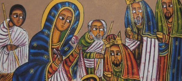
We wish all our friends, customers and our team members across the country a happy Christmas time – Melkam Gena (Happy Christmas know as Gena or Lidet in Ethiopia). As across the Orthodox world it is celebrated a few weeks later than in the west. But this year (2016 which started on 12 Sept), is […]
We wish all or friends, family, supporters and partners Melkam Addis Amet: Happy New Year. Today – as the thirteenth month (Pagume) ends we say goodbye to 2015 and welcome in 2016 in the Ethiopian Calendar. In this past year (2015), known as a Lukas year, (there is one for each of the four evangelists) […]